Muhammad al-Idrisi: Geographer of the Norman Court
Al-Idrisi (c. 1100-c. 1165) was an Andalusi-Maghribi geographer who worked at the court of Roger II of Sicily. His Nuzhat al-Mushtaq, with seventy sectional maps and a world map, was the most detailed geographical description of the world produced in the medieval period.
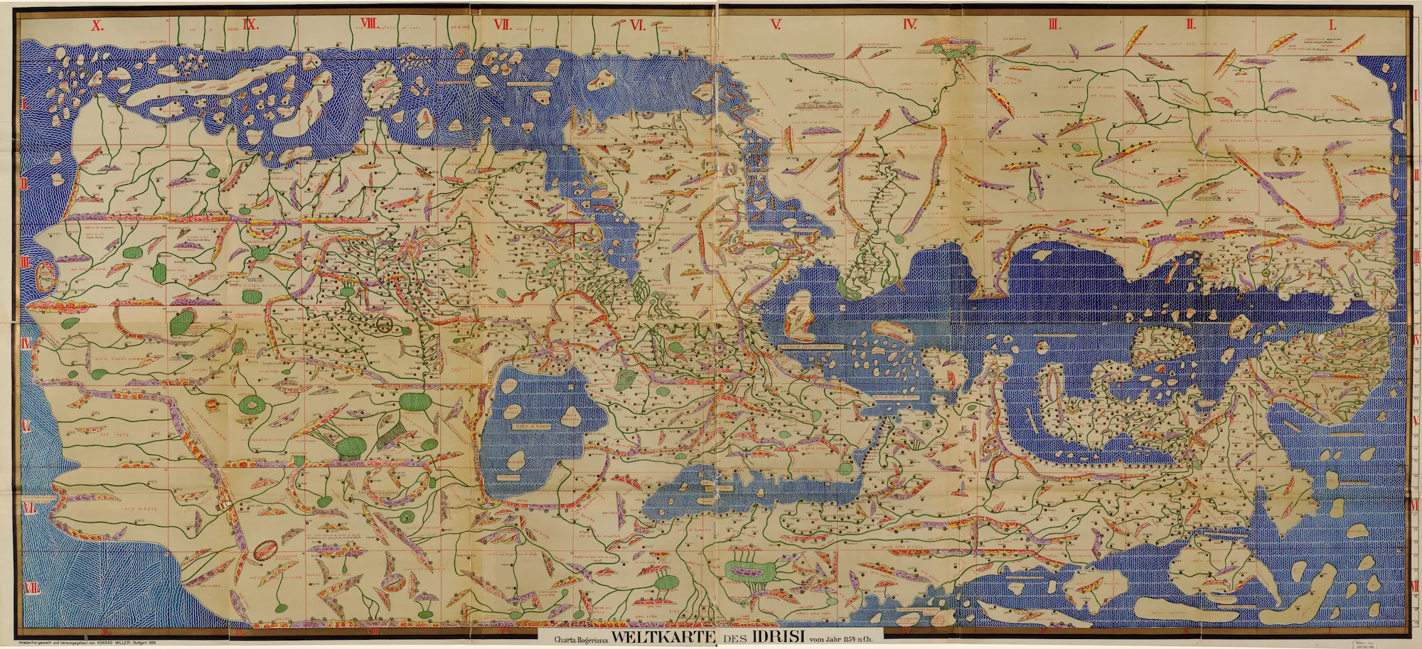
Abu Abdallah Muhammad al-Idrisi al-Qurtubi al-Hasani al-Sabti, who lived from about 1100 to about 1165, produced at the court of a Christian king in Palermo the most comprehensive geographical work of the medieval world. Its Arabic title, Nuzhat al-Mushtaq fi Ikhtiraq al-Afaq, means something like "The Recreation of One Who Longs to Traverse the Horizons"; in Latin Europe it became known as the Book of Roger, and the world map that accompanies it as the Tabula Rogeriana.
The circumstances of its production are as remarkable as its contents. Al-Idrisi was a Muslim scholar of Andalusi and Maghribi background, descended from a displaced princely family, who spent the productive part of his career in the service of Roger II, the Norman ruler of Sicily — a Christian monarch governing a kingdom with a large Muslim and Greek population through a trilingual administration. The work was commissioned by Roger, compiled over some fifteen years with resources the king supplied, written in Arabic, and completed in January 1154, a few weeks before Roger's death.
What resulted was not simply a map. It was a systematic description of the inhabited world in seventy sections, each with its own regional map, covering physical geography, cities, routes, distances, products, peoples and political conditions, and accompanied by a map of the whole world. For accuracy and detail it had no rival in Europe or the Islamic lands for several centuries. The article on Islamic astronomy and navigation sets out the scientific tradition it drew on, and the article on Islamic influence on Europe describes the wider transmission of which it forms part.
Family and Origins
Al-Idrisi was born around 1100 at Ceuta, the port on the North African side of the Strait of Gibraltar, then under the control of the Almoravid dynasty. The nisba al-Sabti derives from the Arabic name of the town, Sabta.
His family history explains the other two elements of his name. They were Hammudids, a branch of the Idrisid house that had ruled in Morocco from the late eighth century and that claimed descent from the Prophet's grandson al-Hasan — hence al-Hasani. A Hammudid line had held Málaga in al-Andalus during the period of the party kingdoms that followed the collapse of the caliphate of Córdoba, and when Málaga fell to the Zirids of Granada the family was displaced and settled at Ceuta. The nisba al-Qurtubi, "of Córdoba", reflects the family's Andalusi standing and his own education there.
Two observations follow, and both matter for reading him.
The descent claim is a claim of lineage, not of sectarian allegiance. Descent from al-Hasan was asserted by many Sunni families across the Islamic west, and the Idrisids were a Sunni dynasty; some modern reference works have described al-Idrisi as a Shia on the strength of the nisba, and the inference is unwarranted. His religious affiliation is not established by the evidence, and this article does not assert one.
His background was that of a displaced aristocracy — a family with royal pretensions, no territory, and the education and connections that came with the first two. That is a plausible part of the explanation for a career spent in the service of a foreign king.
His earliest education took place at Córdoba and at Marrakesh, and Córdoba in the early twelfth century remained a centre of learning even after the political eclipse of al-Andalus described in its own article. He then travelled: along the North African coast, in the Iberian peninsula, and — according to the accounts — more widely around the Mediterranean, with reports placing him in the Holy Lands and Asia Minor and in parts of France and possibly England. The extent of his journeys is not securely documented and later writers have expanded it; what the work itself demonstrates is detailed first-hand familiarity with the western Mediterranean and its coasts.
Norman Sicily
To understand how a Muslim geographer came to work for a Christian king, the kingdom has to be described, because it was unlike anything else in twelfth-century Europe.
Sicily had been under Muslim rule from the ninth century until the Norman conquest completed in 1091. The Normans — descendants of adventurers from northern France who had arrived in southern Italy as mercenaries — took the island without expelling its population, and the kingdom that Roger II consolidated after 1130 governed Muslims, Greek Christians and Latin Christians together.
Its administration was correspondingly plural. Jeremy Johns's study of Arabic administration in Norman Sicily documents a royal chancery issuing documents in Arabic, Greek and Latin, staffed in part by Muslims and by converts, using Arabic fiscal registers inherited from the Islamic period. Alex Metcalfe's work on the Muslims of medieval Italy traces the community's position over the following century. The court at Palermo employed Arabic poets and scholars, the royal workshops produced objects with Arabic inscriptions, and Roger's own coinage and ceremonial borrowed from both Byzantine and Islamic models. Hubert Houben's biography of Roger treats this cultural plurality as a deliberate royal style as well as an administrative necessity.
In Roger's reign the court at Palermo was a place where a Muslim scholar could work with royal support, drawing on the Arabic learning and administrative traditions that the kingdom had inherited from its Islamic period. This is the setting of al-Idrisi's career, and it is the favourable period in which his work was done.
The date of his arrival is uncertain. The accounts connect the commissioning of the geographical project with 1138, while some reference works place his entry into Roger's service around 1145. The disagreement is not resolvable from the evidence, and the safest statement is that he was working at Palermo by the 1140s and that the project occupied roughly fifteen years before its completion in 1154.
The Nuzhat al-Mushtaq
The work al-Idrisi produced consists of a text and a set of maps designed together, and its organisation follows a scheme inherited from Greek geography.
Following the Ptolemaic tradition, the inhabited world is divided into seven climate zones — bands running east to west, numbered from the equator northward. Al-Idrisi divided each of these seven zones into ten sections from west to east, producing a grid of seventy compartments. Each of the seventy has its own map and its own chapter of description. Set alongside them is a map of the world as a whole.
Two features of the cartography are worth noting. The maps are oriented with south at the top, so that north appears at the bottom — standard in the Islamic cartographic tradition of the period and disorienting to a modern eye accustomed to the opposite convention. And the coverage is uneven in a way that reflects the state of knowledge: Europe, North Africa, the Near East and much of Asia are represented in detail, while sub-Saharan Africa is treated only in its northern portions and the southern hemisphere is essentially absent.
The written description is the larger part of the achievement and the part that is often overlooked in favour of the maps. For each section al-Idrisi gives the physical geography — mountains, rivers, coasts, islands — together with the towns and cities, the distances and travelling times between them by land and sea, the routes, the agricultural and manufactured products, the harbours and their conditions, and notes on the inhabitants and the political situation. For the twelfth-century Mediterranean, and for large parts of Europe and western Asia, it is the fullest descriptive geography that survives from any source.
His method combined three kinds of material, and the third is what distinguishes the work.
He used the Greek geographical inheritance, principally Ptolemy, for the mathematical framework of climates and coordinates. He used the substantial Arabic geographical literature that had developed since the ninth century — the route-books and administrative geographies, the descriptive works of writers such as al-Mas'udi, and the Andalusi geographical tradition — as his textual base. And he used first-hand testimony gathered systematically: the accounts describe informants questioned about the regions they knew, with Roger's resources used to obtain reports from travellers and to check one account against another. The sources present this as a deliberate procedure of collection and comparison rather than incidental enquiry, and it accounts for the work's detail on regions that no earlier Arabic geography had described adequately, northern and western Europe among them.
Alongside the book, a large planisphere was made for Roger — a disc of silver, reported at some four hundred pounds in weight, engraved with the world map and showing the trade routes and detailed measurements. It has been described as the world's first globe. The object did not survive the twelfth century and is known through the account of it rather than from the piece itself, but the making of it is recorded as part of the same royal project as the book.
The geographical picture the work presents rests on the understanding that the earth is a sphere, a point the text states directly. Al-Idrisi worked, in this, within the settled learning of the Muslim geographers and astronomers of his age, for whom the sphericity of the earth was long established.
What the Seventy Sections Look Like in Practice
The scale of the Nuzhat al-Mushtaq is easier to grasp from a single compartment of the grid than from a description of the whole, and the treatment of Britain serves the purpose well — partly because it is a region al-Idrisi never saw, so it shows the method working at the limit of his information, and partly because it can be checked against independent English evidence for the same decades.
Britain falls in the seventh climate, the northernmost band, in the first and second of its ten sections. The consequences of the south-up orientation are immediately visible in the resulting map: Scotland appears at the bottom of the sheet rather than the top, drawn as a peninsula attached to the larger landmass rather than as part of a single island, and Cornwall extends as a long narrow spur which the text likens to a bird's beak. The outline is recognisable without being accurate, which is roughly what one would expect from a compilation built out of sailors' reports and earlier written notices rather than from survey.
The written section is the more substantial part. It names towns, states the distances between them and the direction of travel, notes which are large and which small, describes rivers and harbours, and records what each place produced or traded. For a geographer working in Palermo, describing an island at the far edge of the known world from second-hand testimony, the density of named places is considerable — and it is the kind of information that only a systematic programme of questioning informants could have produced. This is where the claim made earlier in this article about al-Idrisi's method can be tested rather than merely asserted. A compiler working only from Ptolemy and the existing Arabic route-books could not have named the towns of eastern England or given the distances between them, because that information was not in those books.
Two points belong with the example. The detail is fullest for the regions nearest the Mediterranean and lighter for those farthest from it, which reflects how far reliable testimony could reach. And the maps as they survive are later copies, so a variation between manuscripts may reflect a copyist's hand rather than al-Idrisi's own drawing. What the case establishes is the character of the enterprise — a comprehensive description of the inhabited world, extending to regions the Arabic tradition had barely touched, assembled by collecting testimony and weighing it.
The Later Work and the Question of the Corpus
Al-Idrisi is credited with a second geographical work, written after Roger's death for his successor William I or William II, generally titled Rawd al-Uns wa Nuzhat al-Nafs — "The Garden of Companionship and Recreation of the Soul". It was apparently larger in conception than the Nuzhat al-Mushtaq.
The textual situation is difficult and readers should know it. The full work does not survive. What exists is an abridgement, transmitted under a related title and often called the "Little Idrisi", whose relationship to the original and whose authorship have been debated; Jean-Charles Ducène's edition and study of its African material is the principal modern scholarly treatment. Statements about the content of al-Idrisi's second geography therefore rest on an abridged and textually uncertain witness, and should be made cautiously.
A work on simple drugs and the properties of plants is also attributed to him in the bibliographical tradition. The attribution is reported and has not been established with the certainty that attaches to the geographical writing, and it is noted here without being relied upon.
His date of death is likewise unsettled. It is usually given as 1165 or 1166, with some scholarship allowing a range extending later; where he died — Sicily or Ceuta — is not established.
Transmission and Influence
The Nuzhat al-Mushtaq survives in about ten manuscripts, ranging in date from the thirteenth century to the seventeenth, of which the most important are held in Paris and Oxford. The maps in them differ, since copyists reproduced them with varying skill and completeness. This is a normal condition for medieval cartographic works, and it has a consequence that is often obscured when the material is reproduced: "the Tabula Rogeriana" — the composite world map, some three and a half metres across when the sections are assembled — is a modern reconstruction from several witnesses rather than a single surviving original, and no sheet drawn in al-Idrisi's own workshop is known to exist. The earliest copies postdate him by a century or more.
Within the Islamic world the work was known and used, though its influence was less than its quality might suggest; the Arabic geographical tradition continued along its established lines, and al-Idrisi's synthesis did not displace the route-books and regional geographies already in circulation. It was consulted by later writers, and the geographical knowledge it represents belongs to the same tradition that produced the navigational and cartographic work described in the article on Piri Reis four centuries later.
In Europe its reception was slower and eventually substantial. An abridged Arabic version was printed in Rome in 1592, and a Latin translation followed in the seventeenth century, under a title that presented it as the geography of Nubia — a misdescription that persisted. From that point it entered European scholarship as a major source for medieval geography, and in the nineteenth century a French translation made it widely available. Its modern scholarly treatment belongs to the history of cartography, where S. Maqbul Ahmad's chapter in the Chicago History of Cartography is the standard account.
The wider significance is the one the article on Islamic contributions to science and medicine describes for the field as a whole. Islamic geography inherited the Greek mathematical framework, added to it the descriptive and route-based knowledge generated by the trade and pilgrimage networks of a world stretching from the Atlantic to China — the networks treated in the article on Islamic trade routes — and produced from the combination a picture of the inhabited world more accurate and more detailed than anything available in Latin Europe. Al-Idrisi's work is the most complete surviving expression of that achievement, and the circumstances of its production at a Christian court make it also a document of the transmission of knowledge between the two worlds.
Historiographical Note
Al-Idrisi presents the opposite problem to most of the scholars treated on this site: the work is substantial and the man is almost undocumented.
There is no contemporary biography. What is known of his life comes from scattered later notices, from the internal evidence of his own writing, and from inference. His birth year is approximate, his death date and place are uncertain, the year he entered Roger's service is disputed, and the extent of his travels rests on claims that later writers expanded without evidence. Even his religious affiliation, which some reference works state confidently, is not established.
The texts themselves raise separate difficulties. The manuscripts of the Nuzhat al-Mushtaq differ, particularly in their maps, so that reconstructing what al-Idrisi actually drew requires comparison across witnesses. The second geography survives only in an abridgement of contested relationship to the original. The silver planisphere is a report, not an object. And the medical work attributed to him is not securely his.
Two interpretative cautions are worth adding.
The first concerns the claim, frequently repeated, that his world map remained the most accurate for three centuries. As a rough characterisation of the descriptive geography it is defensible; as a statement about cartographic accuracy it needs qualification, since the portolan charts developed in the Mediterranean from the late thirteenth century were considerably more accurate for coastal navigation, while serving a different purpose and making no attempt at a world projection. Comparing them is comparing different kinds of document.
The second concerns Norman Sicily. The kingdom's cultural plurality is genuine and well documented: a Latin Christian monarchy that drew on the Arabic and Greek administrative and cultural traditions of the island it governed. Al-Idrisi's career belonged to the reign of Roger II, when the court actively supported Arabic learning, and the conditions of that reign are what made his work possible.
Assessment
Al-Idrisi's achievement is a single work, and it is enough.
The Nuzhat al-Mushtaq is the most complete geographical description of the inhabited world produced anywhere in the medieval period. It combines a mathematical framework taken from Greek science, a textual base drawn from three centuries of Arabic geographical writing, and a body of first-hand testimony collected and cross-checked systematically — a methodology that is genuinely impressive and that accounts for the work's coverage of regions no earlier Arabic geography had described properly. The seventy regional maps and the world map are the most sophisticated cartographic production of their age, and the accompanying text remains a primary source for the twelfth-century Mediterranean and for parts of Europe, Africa and Asia.
Its intellectual character is worth being precise about. Al-Idrisi was a compiler and synthesiser of a high order, working within the Ptolemaic framework he inherited. What he did was assemble more information, from more kinds of source, and organise it more systematically than any geographer before him. In a discipline where the decisive factor was the availability and reliability of information, that was the contribution that mattered, and it is why the work stood without rival for so long.
The circumstances give the work an additional significance. It was produced in Arabic, by a Muslim scholar, for a Latin Christian king, in a kingdom recently conquered from Islam, using resources the king provided — at a period when the Crusades were being prosecuted in the eastern Mediterranean. It is therefore a document of intellectual exchange conducted alongside, and not instead of, armed conflict, and it is a useful corrective to accounts of the medieval Mediterranean that admit only one of those things at a time.
Two points about its reception are worth recording. Within the Islamic world the established route-books and regional geographies continued in wide use, and al-Idrisi's synthesis took its place alongside them rather than displacing them. In Europe the work became known gradually — first through an abridged Arabic printing at Rome in 1592, then through a seventeenth-century Latin translation, and more fully through a nineteenth-century French translation — after which it was recognised as a major source for medieval geography.
Among the figures treated in the article on Muslim scholars who changed the world, al-Idrisi is unusual in that his most important reader was a Norman king and his most lasting audience was European. He belongs to the geographical tradition that also produced Ibn Battuta's account of the fourteenth-century Islamic world and, in a different register, Ibn Khaldun's analysis of the relation between environment and society. Of the three, al-Idrisi is the one whose work can still be laid out on a table and read as a description of the world.
References and Further Reading
Primary Islamic Sources
- Quran, Surah al-Ankabut (29:20) — "Travel through the earth and see how He began creation"; among the verses invoked in the Islamic geographical tradition as a warrant for the study of the world
- Quran, Surah al-Mulk (67:15) and Surah Nuh (71:19–20) — on the earth spread out for travel, texts cited in the prefaces of Arabic geographical works
- Quran, Surah al-Rum (30:9) and Surah Saba (34:18) — on journeying, the distances between settlements, and the observation of former peoples
- Quran, Surah al-Nahl (16:15–16) — on landmarks and the stars by which travellers find their way, the scriptural basis of the link between geography and navigation
- Sahih al-Bukhari and Sahih Muslim, the books of Ilm (Knowledge) and Hajj — the prophetic material on the pursuit of knowledge and on travel, the framework of the rihla tradition
Classical Islamic Sources
- Al-Idrisi. Nuzhat al-Mushtaq fi Ikhtiraq al-Afaq (Kitab Rujar, the Book of Roger) [completed 1154] — his own work, the principal source for both his geography and his method
- Al-Idrisi. Rawd al-Uns wa Nuzhat al-Nafs [after 1154] — his second geography, surviving only in an abridgement of contested transmission
- Ptolemy, Claudius. Geographia — the Greek framework of climates and coordinates that al-Idrisi inherited through the Arabic tradition
- Al-Mas'udi. Muruj al-Dhahab [10th century] — among the Arabic descriptive geographies on which he drew
- Ibn Khurradadhbih. Kitab al-Masalik wa al-Mamalik [9th century] — the route-book tradition underlying his itineraries and distances
- Al-Bakri, Abu Ubayd. Kitab al-Masalik wa al-Mamalik [11th century] — the Andalusi geographical tradition immediately preceding him
- Ibn Battuta. Rihla [c. 1355] — the later travel tradition, for comparison of method
Academic and Scholarly Sources
- Kamal, Ahmad Adel. Atlas of the Islamic Conquests. Riyadh: Darussalam, 2010. From the approved source base; directly consulted for al-Idrisi's origins, education, arrival in Sicily, the silver planisphere, the Book of Roger, and the works attributed to him.
- Ahmad, S. Maqbul. "Cartography of al-Sharif al-Idrisi." In The History of Cartography, vol. 2, book 1: Cartography in the Traditional Islamic and South Asian Societies, ed. J. B. Harley and David Woodward. Chicago: University of Chicago Press, 1992. — the standard scholarly treatment
- Ducène, Jean-Charles. L'Afrique dans le Uns al-muhag wa-rawd al-furag d'al-Idrisi. Leuven: Peeters, 2010. — the critical study of the second geography
- Al-Idrisi's Norman Kingdom in the South. Cambridge: Cambridge University Press, 2025. — recent monograph treatment of the life, times, and works, and of the Nuzhat al-Mushtaq as a product of the Norman Sicilian court
- Johns, Jeremy. Arabic Administration in Norman Sicily: The Royal Diwan. Cambridge: Cambridge University Press, 2002.
- Metcalfe, Alex. The Muslims of Medieval Italy. Edinburgh: Edinburgh University Press, 2009.
- Houben, Hubert. Roger II of Sicily: A Ruler between East and West. Cambridge: Cambridge University Press, 2002.
- Harley, J. B. and Woodward, David, eds. The History of Cartography, vol. 2, book 1. Chicago: University of Chicago Press, 1992.
- Tolan, John, Veinstein, Gilles and Laurens, Henry. Europe and the Islamic World: A History. Princeton: Princeton University Press, 2013.
- Park, Hyunhee. Mapping the Chinese and Islamic Worlds: Cross-Cultural Exchange in Pre-Modern Asia. Cambridge: Cambridge University Press, 2012.
Further Reading
- Abulafia, David. The Great Sea: A Human History of the Mediterranean. London: Allen Lane, 2011.
- Burnett, Charles. Arabic into Latin in the Middle Ages. Farnham: Ashgate, 2009. — on the channels of transmission
- Dunn, Ross E. The Adventures of Ibn Battuta. Berkeley: University of California Press, 1986.
- Norwich, John Julius. The Normans in Sicily. London: Penguin, 2004.
- Savage-Smith, Emilie, ed. Islamic Cartography and Geography, in the Oxford and Chicago reference literature on the sciences in Islam.
More from Medieval Islamic World
Ayyubid Dynasty - Saladin's Legacy and the Unification of the Muslim East
The Ayyubid Dynasty (1171-1260 CE) was founded by Saladin and ruled Egypt, Syria, and Yemen. The Ayyubids recaptured Jerusalem from the Crusaders, promoted Sunni Islam, and created a sophisticated state combining military power with cultural patronage.
Battle of Ain Jalut: Turning Back the Mongol Tide
The 1260 CE battle where the Mamluk Sultanate defeated the Mongol Empire in the Jezreel Valley, marking the first major Mongol defeat and halting their westward expansion into the Islamic heartlands.
Battle of Hattin - Saladin's Decisive Victory
The decisive battle of July 4, 1187 CE, where Saladin's forces crushed the Crusader armies near Hattin in Palestine. This pivotal victory led to the recapture of Jerusalem and marked the beginning of the end of Crusader dominance in the Holy Land.
Fatimid Caliphate (909-1171 CE)
A major Shia Islamic caliphate (909-1171 CE) that ruled North Africa, Egypt, and parts of the Middle East. Founded by the Ismaili Shia dynasty claiming descent from Fatimah, the Fatimids established a powerful empire centered in Cairo rivaling the Abbasid and Umayyad caliphates.