Piri Reis: Cartographer of the Ottoman Sea
Piri Reis (c. 1465-1553) was an Ottoman captain, cartographer and author of the Kitab-i Bahriye, the most detailed sailing guide to the Mediterranean of its age. His 1513 world map, of which a third survives, drew on a chart by Columbus. He commanded Ottoman fleets in the Indian Ocean.
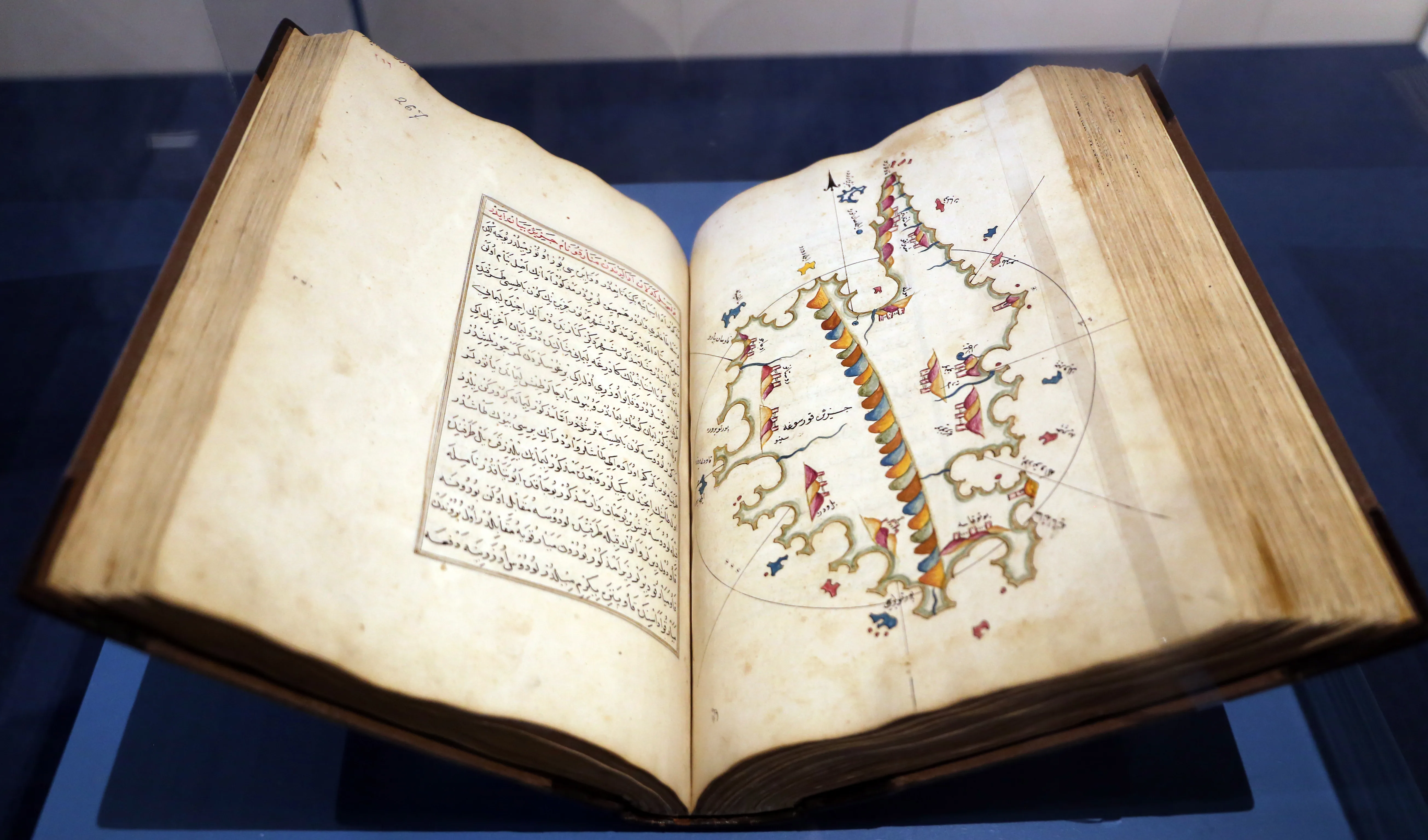
Piri Reis — born Ahmed Muhiddin Piri — was an Ottoman naval captain, admiral and cartographer whose written and drawn work is the most important body of Ottoman geographical material to survive from the sixteenth century. He is known for two things: a world map completed in 1513, of which about a third survives and which drew on a chart made by Christopher Columbus, and the Kitab-ı Bahriye, a systematic sailing guide to the Mediterranean containing some two hundred charts and detailed written directions for its coasts and harbours.
He was also a working sea officer for most of a long life. He served as a young man with his uncle Kemal Reis, a celebrated Ottoman corsair-admiral, fought in the Ottoman–Venetian war at the turn of the sixteenth century, took part in the campaigns of Selim I, and ended his career in his eighties commanding Ottoman fleets in the Red Sea, the Arabian Sea and the Persian Gulf. He was executed at Cairo in 1553.
One matter should be dealt with immediately. The 1513 map has attracted a substantial body of pseudohistorical claim — that it depicts the Antarctic coastline free of ice, and that it therefore records knowledge from a lost advanced civilisation or from sources unavailable to sixteenth-century Europe. These claims do not survive examination of the map itself, which shows a conjectural southern landmass of the kind common in the cartography of the period, and they are rejected by every specialist who has studied the document. They are noted here only so that readers who have encountered them know that they have no standing, and the article does not discuss them further. What the map actually demonstrates is interesting enough.
Life at Sea
Piri was born at Gallipoli, the principal Ottoman naval base on the Dardanelles, at some point between about 1465 and 1470; the date is not established. His family is described as originating from Karaman in central Anatolia and having settled at Gallipoli.
His entry into the naval world came through his uncle Kemal Reis, one of the most successful Ottoman captains of the late fifteenth century, whose career combined corsair operations in the western Mediterranean with imperial service. Piri sailed with him from about 1481, and the apprenticeship lasted some three decades. It included operations along the North African coast and in the western Mediterranean — Kemal Reis was involved in Ottoman contacts with the Muslims of Iberia during and after the fall of Granada — and service in the Ottoman fleet during the war with Venice from 1499 to 1503, in which Piri took part in the naval engagements off the western Greek coast that established Ottoman seapower under Bayezid II.
Kemal Reis died in a shipwreck in 1511. Piri, then in his forties, withdrew from active service for a period and settled at Gallipoli, and it was in these years that he began the cartographic work for which he is now known.
He returned to service under Selim I, taking part in the campaigns that conquered the Mamluk sultanate in 1516–17, and was present in Egypt. He served subsequently in the fleets of Suleiman, including at the siege of Rhodes in 1522, and rose through the ranks of the imperial navy.
The Map of 1513
Piri completed a world map in 1513. What survives is a fragment — roughly a third of the original — showing the Atlantic Ocean, the western coasts of Europe and Africa, and the eastern coasts of South America and the Caribbean. It is drawn on parchment, richly coloured and illustrated, and annotated in Ottoman Turkish. It was found in 1929 in the library of the Topkapı Palace, where it remains.
Its importance rests on its sources, which Piri set out himself in the annotations — an unusual and valuable piece of cartographic self-documentation. He states that he compiled the map from a substantial number of existing charts and world maps, including Portuguese and Arabic sources, older mappae mundi, and, specifically, a map of the western lands drawn by Columbus.
That last point is the map's chief historical value. None of Columbus's own charts of the Caribbean survives, and Piri's map is one of the earliest surviving representations demonstrably derived from Columbus's cartography, which makes it evidence about the lost original. Svat Soucek's study of Piri's mapmaking treats this as the map's genuine significance, and it also indicates how rapidly information about the Atlantic crossings travelled: within about twenty years of the first voyage, an Ottoman captain at Gallipoli had access to Columbian material and incorporated it into a world map.
The map was presented to Selim I in Egypt in 1517, following the conquest. A second world map, of which only a fragment survives showing part of the North Atlantic and Central America, dates from 1528.
The Tradition He Worked In
Piri's achievement is better understood against the cartographic and navigational traditions available to him, which were several and which he combined.
The first was the Islamic geographical tradition, a body of work reaching back to the ninth century and including the mathematical geography developed at Baghdad, the descriptive geographies of the tenth-century travellers and administrators, and the twelfth-century world geography of al-Idrisi, produced in Sicily and among the most sophisticated descriptions of the known world made anywhere before the modern period. This tradition supplied coordinates, place-names, distances and a framework for organising the inhabited world, and its institutional background is described in the article on the Islamic Golden Age.
The second was the practical navigational literature of Muslim seamen, which was strongest in the Indian Ocean. The Arab pilot Ahmad ibn Majid, writing in the late fifteenth century, produced navigational treatises of great technical sophistication dealing with stellar altitudes, monsoon timing, and courses across open ocean — knowledge developed in a sea where voyages were made out of sight of land for weeks, and considerably in advance of Mediterranean practice in that respect.
The third was the Mediterranean portolan chart: the tradition, developed principally in Italian and Catalan workshops from the thirteenth century, of drawing coastlines with high accuracy from accumulated sailing experience, marked with networks of rhumb lines for setting courses by compass. Portolan charts were working documents of remarkable precision for coastal navigation and made no attempt at a projection or at representing the whole globe.
The fourth, and new in his lifetime, was the Iberian material generated by the Atlantic and Indian Ocean voyages — Portuguese and Spanish charts recording coasts no earlier tradition had described.
Piri's two kinds of work correspond to different combinations of these. The Kitab-ı Bahriye is a portolan atlas in conception, extended and systematised far beyond its models by the addition of full written sailing directions for every coast, and grounded in the author's own four decades of Mediterranean sailing. The world maps are compilations in the tradition of the mappa mundi, assembled from many sources including the Columbian material, and intended for a sultan rather than for a pilot. That one man produced both, and documented his sources in the second, indicates a cartographer working deliberately across traditions rather than within one.
The Kitab-ı Bahriye
Piri's major written work is the Kitab-ı Bahriye, the Book of the Sea, and it is a different kind of achievement from the world map: not a display object but a working manual.
He completed a first version in 1521 and then produced a substantially expanded and revised version in 1525 or 1526, which was presented to Suleiman through the grand vizier Ibrahim Pasha. The revised work contains some two hundred charts covering the Mediterranean and Aegean systematically, coast by coast and island by island, each accompanied by written sailing directions.
The content is intensely practical. For each stretch of coast it gives anchorages and their holding ground, the depth of water, hazards — reefs, shoals, currents — landmarks for making a landfall, sources of fresh water, the character of local harbours and their defences, distances and bearings between points, and notes on winds. Interleaved with this is descriptive and historical material about ports, islands and their populations, which makes the work a source for sixteenth-century Mediterranean geography and society as well as for navigation.
The revised version opens with a long verse introduction that includes an account of oceanic navigation, the Portuguese voyages, and the geography of the Indian Ocean and the Atlantic discoveries — material that places Ottoman readers in the world revealed by the Iberian expansion.
Two things are worth saying about the work's standing. It is by a considerable margin the most detailed and systematic guide to the Mediterranean produced in the sixteenth century by anyone, and it was compiled by a man who had sailed the waters he described over some forty years. And it belongs to a genuine Ottoman engagement with the new global geography rather than to isolation from it: Giancarlo Casale's work on Ottoman exploration argues that the empire responded to the Portuguese arrival in the Indian Ocean with sustained interest and a substantial information-gathering effort, of which Piri's writing is part.
Inside the Kitab-ı Bahriye
Because the Kitab-ı Bahriye is Piri Reis's substantial achievement and is far less discussed than the map, its contents deserve description.
The work exists in two versions. The first, completed in 1521, is the more austere: charts with accompanying sailing directions, arranged as a systematic circuit of the Mediterranean. The second, finished in 1525 or 1526 and presented to Suleiman through the grand vizier Ibrahim Pasha, is considerably expanded, opens with a long verse introduction, and is the version in which the work is generally known. Many manuscript copies survive, varying in the number and quality of their charts, which means that statements about "the" Kitab-ı Bahriye always conceal a textual problem.
The body of the work proceeds coast by coast. It begins in the Aegean and the approaches to the Dardanelles, works through the Greek islands and mainland, up the Adriatic, along the Italian coasts, past France and Spain, through the Strait of Gibraltar, then eastward along North Africa to Egypt, the Levant and the southern coast of Anatolia. Each section pairs a chart with written directions.
The written material is relentlessly practical, and its categories are worth listing because they show what a sixteenth-century pilot needed to know: anchorages and the quality of their holding ground; depths and the character of the bottom; reefs, shoals, rocks and other hazards, with bearings for avoiding them; landmarks for identifying a coast and making a safe landfall; sources of fresh water and provisions; the prevailing and seasonal winds and the currents; distances and courses between points; and the condition and defences of harbours, including which were fortified and how strongly. Interleaved with this is descriptive and historical material on ports, islands, ruins and populations, which is why the work is a source for Mediterranean society and topography as well as for navigation.
The verse introduction to the second version ranges much more widely. It deals with the compass and the practice of navigation, with winds and storms, with the great oceans, and then with the geography revealed by the Iberian voyages: the Portuguese route around Africa to India, the Atlantic crossings and the lands found beyond them, China, and the Indian Ocean. This material establishes that its author had a considered picture of the new global geography and thought it worth putting before a sultan.
Two judgements about the work can be made with confidence. As a practical guide it has no equal from the sixteenth century in any language for the completeness and system with which it covers the Mediterranean, and it was compiled from the author's own four decades of sailing rather than assembled from other men's reports. And as a historical source it is now indispensable: for many sixteenth-century harbours, coastal settlements and fortifications, Piri Reis's description is the fullest that survives. Svat Soucek's study is the standard scholarly treatment.
The Ottoman–Portuguese Contest in the Indian Ocean
Piri Reis's last command belongs to a struggle that ran for most of the sixteenth century, and its structure explains why his Gulf expedition failed.
The Portuguese entered the Indian Ocean in 1498 and within two decades had built a system: fortified bases at Goa, taken in 1510, Malacca in 1511, and Hormuz commanding the mouth of the Persian Gulf in 1515, together with positions on the East African and Arabian coasts and a policy of licensing and taxing — or destroying — the shipping that had previously carried the Indian Ocean trade. The strategic object was to divert the spice trade around the Cape of Good Hope and away from the Red Sea and Gulf routes.
That threatened Ottoman interests directly. The conquest of the Mamluk state in 1516–17 had given Selim I Egypt, Syria and the Red Sea, and with them the customs revenues of the eastern trade and the responsibility for the pilgrimage routes to Mecca and Medina. A hostile fleet at the mouth of the Red Sea was both a commercial and a religious problem.
The Ottoman response was to build a fleet at Suez and contest the western Indian Ocean. Its principal episodes: an expedition under Hadım Süleyman Pasha in 1538 which took Aden and failed before the Portuguese fortress at Diu; Piri Reis's recovery of Aden in 1548 and his Gulf expedition of 1552, which took Muscat and failed at Hormuz; the destruction of a further Ottoman fleet off the Gulf in 1554, whose commander Seydi Ali Reis wrote an account of his subsequent overland return; and later operations in the Red Sea and along the East African coast into the 1580s.
The pattern of failure was consistent, and it was structural rather than a matter of individual competence. Ottoman naval power was built on galleys, which were designed for the Mediterranean: shallow-draught, oar-driven, with almost no capacity to carry provisions and water for their large crews, and therefore dependent on friendly harbours every few days. In the Indian Ocean the distances were far greater, the monsoon governed the sailing season absolutely, and the enemy held a chain of fortresses that denied the intermediate harbours a galley fleet required. Portuguese ships, by contrast, were ocean-going sailing vessels carrying heavy guns and able to stay at sea for months.
The logistics compounded the problem. Suez and Basra had no local timber; shipbuilding materials had to be carried overland or brought from Anatolia and the Black Sea forests, which made every fleet enormously expensive and every loss difficult to replace. Salih Özbaran's and Giancarlo Casale's studies of the Ottoman engagement with the region show a state making a serious, sustained and well-informed effort against a problem it lacked the technical means to solve.
Seen in that light, Piri Reis's decision in 1552 to break off the siege of Hormuz and withdraw to Basra, and then to return to Egypt with three ships and the accumulated plunder, looks less like dereliction than like a recognition of what was achievable. The Ottoman governor of Egypt took a different view, and he was executed for it in 1553.
The Indian Ocean Command
The last phase of Piri's career took him to a different sea and to the confrontation that had been developing since the Portuguese entered the Indian Ocean in 1498.
The Portuguese had established fortified positions across the western Indian Ocean — at Hormuz commanding the Persian Gulf, at Diu and Goa in India, and at points along the East African and Arabian coasts — and were attempting to control the spice trade and to divert it around the Cape, at the expense of the Red Sea and Gulf routes on which Ottoman Egypt and Syria depended. The Ottoman response was to build and maintain a fleet at Suez and to contest the Portuguese position. Palmira Brummett's study of Ottoman seapower examines the commercial and strategic stakes.
Piri was appointed commander of the Ottoman fleet in the Indian Ocean — the office rendered as Hint Kaptanı, captain of India — in 1547, when he was around eighty. He operated from Suez, and in 1548 he recovered Aden, the fortress commanding the entrance to the Red Sea, which was essential to the security of the whole Ottoman position in the region.
In 1552 he took a fleet from Suez into the Persian Gulf. He took Muscat from the Portuguese, raided their positions, and laid siege to Hormuz, the key to the Gulf. The siege failed — Hormuz was strongly fortified and Ottoman resources at that distance were inadequate — and Piri withdrew to Basra with his fleet and considerable plunder.
He then returned to Egypt with three ships and the treasure, leaving the bulk of the fleet at Basra. The Ottoman governor of Egypt held him responsible for abandoning the fleet and for refusing to assist a further operation, and he was executed at Cairo in 1553, at about eighty-eight.
The end is abrupt and the reasoning behind it is not fully recoverable from the sources. What is clear is that an admiral of enormous experience was put to death for a decision taken in a theatre where Ottoman logistics were stretched past their limit, and that the Ottoman position in the Gulf did not improve afterwards.
Historiographical Note
Piri Reis is unusual among the subjects of this period in that his own work is the principal source for his significance, while his biography is thin.
The Kitab-ı Bahriye and the surviving map fragments are primary documents of his making, and they can be examined directly. The map's annotations state his sources; the Bahriye records his knowledge of the Mediterranean and something of his career. This is a far better evidential position than exists for most sixteenth-century Ottoman sailors.
His life, by contrast, is documented sparsely: Ottoman chancery and arsenal records for appointments, Katip Çelebi's seventeenth-century naval history, and scattered references in the chronicles. His birth year is uncertain within about five years, the details of his service under Kemal Reis are largely inferred from his own remarks, and the circumstances of his execution are reported briefly and without a full account of the charges.
Svat Soucek's study is the standard scholarly treatment of the cartography and is the appropriate corrective to the popular literature. That popular literature is a genuine problem in this case: the 1513 map has been the subject of pseudohistorical writing since the mid-twentieth century, and a reader searching for information about Piri Reis will encounter a good deal of it. The claims about an ice-free Antarctic coastline rest on misreading a conjectural southern landmass of a type standard in period cartography, and on treating the map's coastlines with a precision they do not possess. No specialist in the history of cartography accepts them. The effect has been to obscure the map's real interest, which is its transmission of Columbian material, and to distract from the Kitab-ı Bahriye, which is the more substantial work.
Assessment
Piri Reis's importance is documentary, and it is greater than that of most of the commanders he served under.
The Kitab-ı Bahriye is his principal achievement. As a body of practical knowledge it was the best guide to the Mediterranean available in the sixteenth century, more detailed and more systematic than anything produced in Christian Europe at the same date, and it was compiled from four decades of the author's own sailing rather than assembled from other men's reports. As a historical source it is now indispensable: for the harbours, defences, populations and coastal conditions of the sixteenth-century Mediterranean, it is often the fullest description that exists.
The 1513 map matters for a narrower but real reason. It preserves, at second hand, cartographic information from Columbus that is otherwise lost, and it demonstrates that knowledge of the Atlantic discoveries reached the Ottoman naval establishment quickly and was actively incorporated there. Both points bear on the larger question of whether the Ottoman Empire was engaged with or insulated from the European age of exploration, and the evidence of Piri's work is that the engagement was serious.
As a commander his record is competent rather than distinguished. He spent most of his career in subordinate positions, and his independent commands came when he was very old: Aden in 1548 was a solid success, and the Gulf expedition of 1552 achieved raiding gains and failed at its principal objective. The failure at Hormuz was probably not his fault — the Ottomans never solved the problem of projecting force from Suez and Basra against fortified Portuguese positions, and the distances and supply difficulties defeated better-resourced attempts than his. His execution for withdrawing with three ships and the plunder looks, on the available evidence, like a governor finding someone to blame for a strategic impossibility.
There is a wider point in the shape of his career. Piri Reis spent his working life in the Mediterranean, mapping it more thoroughly than anyone had, and was sent in old age to a sea where the Ottoman Empire could not sustain what it attempted. The empire's naval strength was regional, resting on galleys, short distances and secure bases, and it did not translate to the Indian Ocean, where the Portuguese had oceangoing ships and a chain of fortresses. That the most knowledgeable Ottoman seaman of the century died under sentence for failing in the Gulf is a comment on the limits of Ottoman seapower rather than on him.
His name is now attached to the map, which is the least representative part of his work, and largely for reasons that have nothing to do with what the map shows. The Kitab-ı Bahriye is the achievement, and it deserves to be the basis of his reputation.
References and Further Reading
Primary Islamic Sources
- Quran, Surah al-Isra (17:66) — "It is your Lord who drives the ship for you through the sea"; among the verses cited in the opening sections of Ottoman maritime works
- Quran, Surah al-Rahman (55:24) — on the ships that run upon the sea, a text conventionally invoked in navigational writing
- Quran, Surah al-Jathiyah (45:12) and Surah Fatir (35:12) — on the subjection of the sea to human use and the two seas, verses used in Ottoman geographical prefaces
- Quran, Surah al-Alaq (96:1–5) — on knowledge, the text underlying the scholarly framing of Ottoman scientific writing
- Sahih al-Bukhari, Kitab al-Jihad wa al-Siyar — the prophetic material on naval expeditions, cited in the Ottoman literature on maritime service
Classical Islamic Sources
- Piri Reis. Kitab-ı Bahriye. [1521; revised 1526] — his own work, the principal primary source
- Piri Reis. World map of 1513. Topkapı Palace Library, Istanbul. — the surviving fragment, with the author's annotations on his sources
- Piri Reis. World map fragment of 1528.
- Katip Çelebi. Tuhfat al-Kibar fi Asfar al-Bihar. [17th century] — the Ottoman naval history, for his later career
- Ibn Majid, Ahmad. Kitab al-Fawaid fi Usul Ilm al-Bahr wa al-Qawaid. [late 15th century] — the great Arab navigational treatise on the Indian Ocean, the tradition Piri's Gulf command operated within
- Sidi Ali Reis. Mirat al-Mamalik. [1557] — the account of a successor in the Indian Ocean command
- Ottoman arsenal and chancery registers recording his appointments and the Suez fleet
Academic and Scholarly Sources
- Soucek, Svat. Piri Reis and Turkish Mapmaking after Columbus. London: Nour Foundation, 1996. — the standard scholarly study of the maps and the Bahriye
- Casale, Giancarlo. The Ottoman Age of Exploration. New York: Oxford University Press, 2010. — on Ottoman engagement with the Indian Ocean and global geography
- Brummett, Palmira. Ottoman Seapower and Levantine Diplomacy in the Age of Discovery. Albany: State University of New York Press, 1994.
- Bostan, İdris. Ottoman Maritime Arsenals and Shipbuilding, and related studies on Ottoman naval organisation.
- Özbaran, Salih. The Ottoman Response to European Expansion. Istanbul: Isis Press, 1994. — on the Gulf and Red Sea campaigns
- Harley, J. B. and Woodward, David, eds. The History of Cartography, vol. 2, book 1: Cartography in the Traditional Islamic and South Asian Societies. Chicago: University of Chicago Press, 1992.
- Guilmartin, John F. Gunpowder and Galleys. Cambridge: Cambridge University Press, 1974. — on why Mediterranean galley forces did not transfer to oceanic warfare
- Subrahmanyam, Sanjay. The Portuguese Empire in Asia, 1500–1700. 2nd ed. Chichester: Wiley-Blackwell, 2012.
Further Reading
- İnalcık, Halil. The Ottoman Empire: The Classical Age, 1300–1600. London: Weidenfeld and Nicolson, 1973.
- Braudel, Fernand. The Mediterranean and the Mediterranean World in the Age of Philip II. 2 vols. London: Collins, 1972–73.
- Goodrich, Thomas D. The Ottoman Turks and the New World. Wiesbaden: Harrassowitz, 1990.
- Emiralioğlu, Pınar. Geographical Knowledge and Imperial Culture in the Early Modern Ottoman Empire. Farnham: Ashgate, 2014.
- Crowley, Roger. Empires of the Sea: The Final Battle for the Mediterranean, 1521–1580. London: Faber, 2008.
Mentioned In
6 articles reference this topic
More from Ottoman Empire
Ottoman Empire (1299-1922 CE)
The Ottoman Empire ruled for over 600 years, spanning three continents at its height. Founded by Osman I in 1299 CE, it became one of history's most powerful empires, serving as the seat of the Islamic Caliphate from 1517 until 1922.
Topkapi Palace - Heart of the Ottoman Empire
Topkapi Palace (1459-1856 CE) served as the primary residence and administrative headquarters of Ottoman sultans for nearly four centuries. Located on Seraglio Point overlooking the Bosphorus, this vast complex represents the pinnacle of Ottoman architecture and imperial power.
Battle of Nicopolis (1396 CE)
The Battle of Nicopolis, fought on 25 September 1396, was a decisive Ottoman victory over a combined Western European crusading army under Sigismund of Hungary. The last major crusade of the medieval period, its failure cemented Ottoman dominance over the Balkans.
Blue Mosque: The Sultan Ahmed Mosque of Istanbul
The Blue Mosque (Sultan Ahmed Mosque) in Istanbul, built between 1609-1616 CE, is one of the most magnificent examples of Ottoman architecture and a masterpiece of Islamic architectural achievement.